Hastings Flooding: History shows Priory Meadow was once a soggy marsh
and live on Freeview channel 276
He writes: ‘A Disaster Waiting to Happen’ was the headline on the front page of last week’s Observer. And it was a tragedy that was widely-predicted long before the shopping centre was built, but the warnings were ignored by Hastings Council.
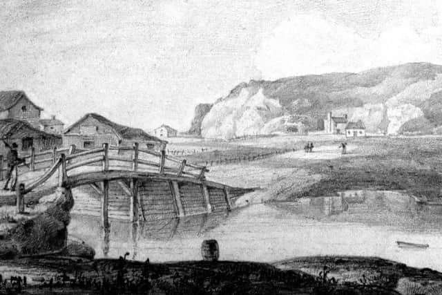
Even William the Conqueror knew it was not a good place to build on, as back in 1066 it was a deep-water harbour, the ideal base for his cross-Channel invasion. The drawing shows how Hastings might have looked at the end of the 11th century, with the town of Hastings on White Rock. The valley between White Rock and the castle, where the town centre is today, was created by streams coming down off the surrounding high ground inland and scouring out the low-lying soil to create a natural port.
Advertisement
Hide AdAdvertisement
Hide AdIn the following centuries the valley silted up and became unusable as a harbour, but it remained marshy and liable to flood in strong gales. The valley became known as the Priory Valley after a priory was set up in about 1190 where Cambridge Gardens is today, but it had to move inland in 1471 because of flooding.

In 1580 members of the local establishment received a large grant from the Crown to try to turn the Priory Marsh into a ‘haven’, a closed-in dock, which could be used by large trading vessels. Using half the grant, a sea-defence embankment of rock and soil was built across two-thirds of the bottom of the valley, roughly where Cambridge Road is now, but then the scheme was abandoned and the rest of the money disappeared.
This embankment played a key role in the future of the Priory Valley, and therefore today’s town centre. In half-building the haven, the contractors dug out the ground going as far inland as where South Terrace is today, with the embankment stopping it draining properly. In following years the haven filled with soil brought down from the surrounding hills, which remained permanently wet and soggy, and clearly not possible to build on.
The setting up of the America Ground on the seaward side of the embankment in the early 1800s and the creation of today’s Cambridge Road in the late 1830s, both left the Priory Marsh as open ground. Development started taking place around the haven in the 1850s, but the land at the heart of it was so unusable that it was turned into a cricket ground. And then came the Priory Marsh (sorry – Meadow) shopping centre.
Advertisement
Hide AdAdvertisement
Hide AdThe history of the floodable Priory Marsh is in my book The America Ground, published by The History Press in 2001. Ironically, it is on sale in Waterstones and WH Smith, both of which had to close temporarily because of the flooding!
Have you read? The Hastings family who once lived in a cave