Albourne 120-home development plans submitted
and live on Freeview channel 276
Croudace wants planning permission for two large agricultural fields south of Henfield Road and north of Church Lane.
Land would be reserved for a possible expansion of Albourne Primary School and the southern portion of the site would be earmarked for parkland.
Advertisement
Hide AdAdvertisement
Hide AdAn outline application has been submitted to Mid Sussex District Council.
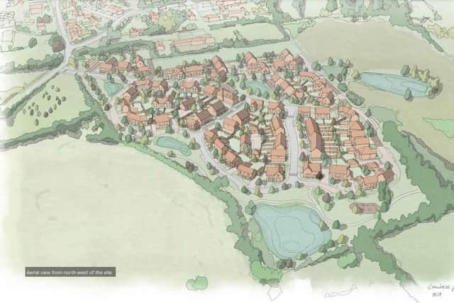

As well as 30 per cent affordable housing, the scheme includes a community shop in the north-east corner, play area and dedicated car park/drop off area for parents.
Access to the site would be from Henfield Road.
The developer believes the car park/drop off area for the school, which would operate internally with a one-way system, would divert traffic away from The Street, a narrow residential road which suffers from congestion.
The existing orchard on the northern edge of the site would be ‘protected and enhanced’.
Advertisement
Hide AdAdvertisement
Hide AdThe application added: “The development does not propose built form on the southern field. Instead, the Applicant is seeking to implement a landscape strategy to open up the land south of the public footpath for public use. The landscape scheme proposes new woodland and orchard, species rich meadow, new planting, walking routes and seating areas so that this area can be enjoyed by future residents, the wider Albourne community, and those using the existing Public Rights of Way.”
The developers argues that MSDC’s local plan is approaching five years old and housing need in the district has ‘significantly increased’ and while new homes are coming forward they are ‘not at the pace expected or of sufficient quantity’.
In its application it points out Albourne is a category 3 settlement in the hierarchy meaning it is a ‘medium sized village’. Meanwhile the site is contiguous to the settlement boundary and while not currently in a development plan ‘is clear that it would help meet the needs of present and future generations in a local considered sustainable by the Local Plan’.
The application concludes: “The development has been designed to ensure it integrates as much as possible with the surrounding landscape. Limiting development to the least sensitive part of the site ensures valued views are retained and enhanced, and that adverse impacts are kept to a minimum.
To comment, visit www.midsussex.gov.uk/planning using code DM/22/2416.