Historical map challenge tests knowledge of Sussex town
and live on Freeview channel 276
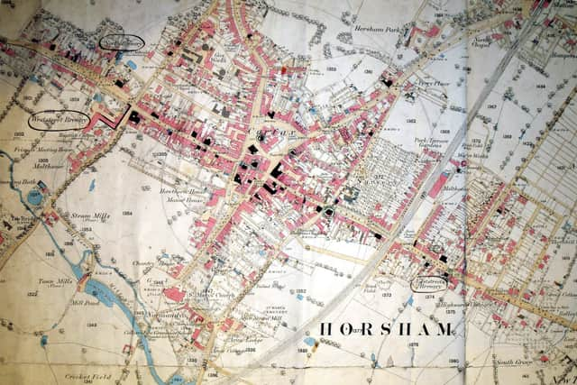
Horsham Museum & Art Gallery heritage manager Jeremy Knight has been exploring the Tithe Map, produced in 1841 and revised in 1846, and explains it does have some drawbacks.
He compares it to the Ordnance Survey map of around 1875, used by solicitors to plot licensed premises, and has come up with a list of challenges and things for people to find to test their knowledge of the town.
Advertisement
Hide AdAdvertisement
Hide AdJeremy said: “It is a fantastically detailed map. It is an extremely useful resource but has some drawbacks. It is extremely large, filling a room, and only three copies were made.


“Whilst a map that related to Horsham Parish and town had been drawn up as an attachment to the 1832 Reform Act, it lacked real detail. Very few people would have had access to a copy of the act, thus making this map all the more important.
“Maps were originally produced for individuals, often to fulfil a particular purpose such as clarifying land ownership or for showing off one’s estate.
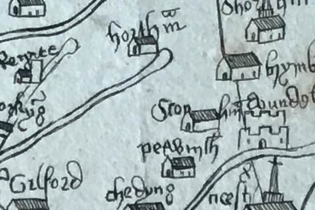
“Horsham appears on the best medieval map of Britain, the Gough map, an engraved copy of which done in 1780s of the map. For some reason, the hamlet of Stopham is shown on the map but a number of larger settlements are not.”
Advertisement
Hide AdAdvertisement
Hide AdHave a look at www.goughmap.org for more detailed information on this amazing but largely-forgotten map.


Jeremy continued: “At the time that the Tithe Map was produced, it was not the norm to produce maps with everything in, even today maps are selective.
“If you look at the legend or key on a modern Ordnance Survey map you will easily see what they have decided to focus on, and also what they have decided to leave out. A key may tell you what type of trees grow in a wood but not the species of fish found in a lake, or the type of paving material used on a road. For example, the map of Horsham produced in 1816 shows only the property that the Duke of Norfolk was interested in, as it was commissioned by the Duke himself.
“The Tithe Map was very detailed because it dealt with taxes and who owned what land was important in determining the amount to be paid.
Advertisement
Hide AdAdvertisement
Hide Ad“Another map, produced in 1875 by the Ordnance Survey, covered a wider area than the Tithe Map and was available in a single foldable, or roll, sheet. This later map enables the viewer to put themselves in context of the town at the time.


“Horsham is fortunate in that it has four streets that give their magnetic direction, North Street, West Street, East Street and South Street. However, when you move away from those streets, it is more difficult to understand how the road you are in relates to other roads.
“This map changed the way people thought about the town, the mental geography. Most people think of distance in time taken to walk or drive, or they think of places by how they got there. A classic example of this is the London Underground map, it is highly simplified and easy to understand but has very little bearing to the layout of the land above ground.”
Now that you know more about the context of these historic maps, Jeremy has come up with some challenges, so you can have some fun exploring the Ordnance Survey map c1875:
Find the old Town Hall before it was partially rebuilt.
Advertisement
Hide AdAdvertisement
Hide AdWhere is the town’s first swimming bath? It used a concrete disc to heat a shallow layer of water that then emptied into the pool. This heating system was a commercial failure.
Find the large town nursery, a well-known landmark that is now buried under housing.
Look for Collyers. It moved to its current site in 1893, before the move it stood on its original site from the 1540s.
Can you find the rifle club? The rifle club was clearly of interest to the Ordnance Survey whereas other clubs were less so and are therefore not shown.
Advertisement
Hide AdAdvertisement
Hide AdLocate the Gaol Green. The green was a hangover from when the Gaol was originally located on that site in the 1400s.
Spot the gas works. The works used coal to create gas which was used for street lighting from 1836.
The water works should be somewhere on the map. It was a private venture that eventually had to be bought out by the Local Board of Health.
A message from the Editor, Gary Shipton:
In order for us to continue to provide high quality and trusted local news, I am asking you to please purchase a copy of our newspapers.
Advertisement
Hide AdAdvertisement
Hide AdWith the coronavirus lockdown having a major impact on many of our local valued advertisers - and consequently the advertising that we receive - we are more reliant than ever on you helping us to provide you with news and information by buying a copy of our newspapers.
Our journalists are highly trained and our content is independently regulated by IPSO to some of the most rigorous standards in the world. But being your eyes and ears comes at a price. So we need your support more than ever to buy our newspapers during this crisis.
Stay safe, and best wishes.