


Following weeks of relentless rainfall, a major road closure remains in place, with highway improvement plans also delayed, as emergency services and council workers battle rising water levels.
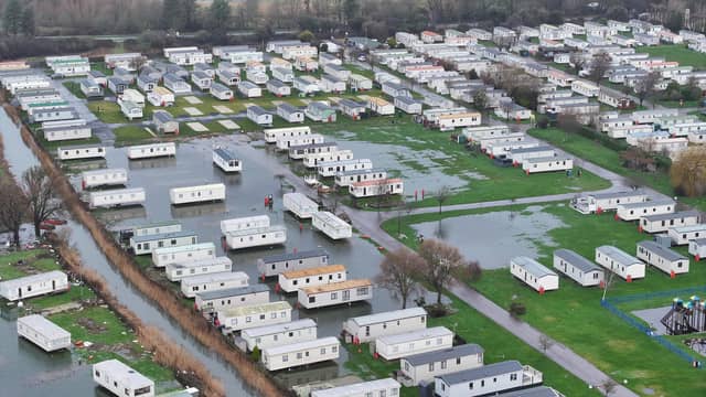
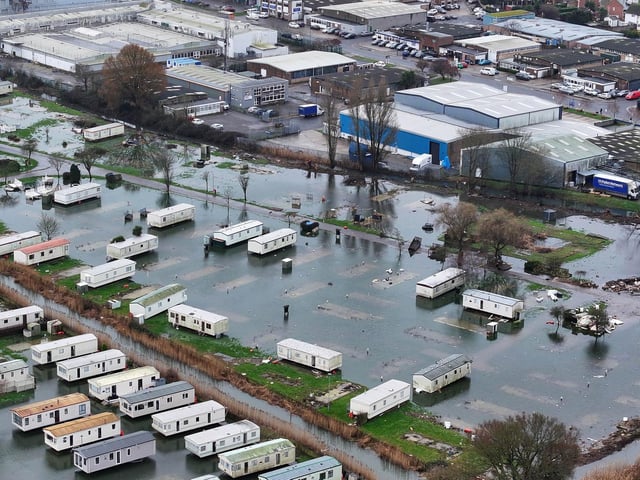
Meanwhile, dramatic photos appeared to show entire rows of homes partially submerged at Riverside Caravan Park, on Shripney Road, on Tuesday afternoon (February 10).
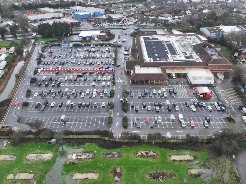
Emergency pumping equipment was set up in the Tesco superstore car park, across the road, to help deal with rising water levels on Tuesday.
The aerial images showed floodwater stretching across large areas of the site, engulfing pitches and surrounding parked caravans, as water levels continued to rise.
The caravan site management team has since told the Observer: “Riverside has experienced a limited amount of surface water following recent weather conditions. This is not unusual for this time of year and is something the park has historically managed without issue. Water levels have already begun to recede and have not reached, nor are they expected to reach, a level that would pose any risk to caravans or park infrastructure.
"The area featured in the published images and footage is not currently in operational use, there has been no impact on our day-to-day park activities and we do not expect that to change. Riverside is scheduled to reopen on 1st March and will resume normal operations from that date."
The flooding comes after sustained wet weather across the county, which has already caused disruption in several low-lying locations. Residents and businesses nearby are being urged to remain alert as conditions remain challenging.
An Environment Agency spokesperson said: “We are aware of flooding affecting a caravan park in the Bognor Regis area and our sympathies go out to all those affected. We are actively warning and informing residents of the developing flood risk through our flood warning service.
“To protect the West Sussex area, our EA teams are responding quickly to reports of blockages, clearing debris screens in Barnham, and our pumps at Felpham are running to help water pass through the rivers as smoothly as possible. We also have community information officers in the area this week speaking with residents.
“Our maintenance approach focuses on vegetation management, with two weed boats, which to opens channels and increase water flow away from communities.
“Our teams are on duty around the clock to clear blockages and respond to emergencies.”
The EA confirmed the pump was installed and is operated by Tesco, adding: “We were not involved with the operation or deployment of the pump.
“Members of the public can call our free 24/7 floodline service on 0345 988 1188 for help and advice.”
Meanwhile, a highway operative escaped unharmed after being 'struck' by a car on the A29.
The vehicle is said to have 'forced its way through’ the road closure, according to West Sussex County Council (WSCC).
The incident happened on A29 Shripney Road – at the Saltbox Roundabout – in Bersted. The road has been closed since Monday, February 2, due to major flooding.
The latest update was posted by West Sussex Highways at 1pm on Wednesday. This read: “Our contractors have finished installing a temporary ramp over the flooding at Sack Lane to enable vehicle access for all residents. This will remain in place until the weather conditions improve and the road is clear of flood water.
"Shripney Road will remain closed to all non-residents and non-local business users due to the current water level.
“We are working on site to try and relieve the wider flooding issues on the A29 and will provide further updates as necessary. We thank residents for their patience and understanding.”
As result, a community highway scheme – due to start on Monday, February 16 – has been delayed.
A previous announcement of the planned works prompted criticism from some residents, who questioned why flood management and drainage issues were not being prioritised.
The ongoing flooding reflects long-standing issues in the area, according to county and district councillor Keir Greenway, a lifetime resident of Bersted. Following widespread flooding in October and November 2023, a formal Section 19 flood investigation examined why Shripney is particularly vulnerable.
“Shripney sits in a low-lying catchment, with water naturally draining through the Shripney Manor Ditch into the slow-flowing Aldingbourne Rife,” Cllr Greenway said. “The village also relies heavily on roadside drainage (ditches, pipes and gullies) to move water away during heavy rain."
He said the 2023 flooding was caused by several overlapping factors rather than a single failure.
“Exceptional rainfall from multiple storms fell on already saturated ground, groundwater levels were already high, and the Shripney Manor Ditch exceeded its capacity and came out of bank,” he said.
“When the ditch is full, highway drains can’t discharge properly, so water backs up and surcharges onto the road. At the same time, the foul sewer system was overwhelmed and discharging from manholes, and some highway gullies were partially blocked by silt and tree root intrusion.”
Cllr Greenway warned that climate change is increasing the likelihood of similar events in the future.
An updated Environment Agency flood alert, for the Aldingbourne and Barnham Rifes, reads: “High river levels on Thursday may lead to flooding.
“Flooding is possible on 12 February, as another 10mm of rain is forecast on Wednesday evening.
“The Aldingbourne Rife is high following weeks of rain. Minor flood impacts affecting fields, roads, land at Riverside Caravan Centre, and the car park at Tescos on Shripney Road will continue. A band of rain is forecast on Wednesday evening.
"From 8pm Wednesday, minor flood impacts could affect Barnham Road and Lake Lane, Barnham. The Barnham Rife should not rise higher than Friday. Through Thursday, the Aldingbourne Rife should rise less than ten centimetres before beginning to fall in Bersted by Thursday evening, although it will not fall far or fast. Further river rise is possible Friday.
“We are closely monitoring the situation .We're clearing debris screens in Barnham and pumps at Felpham are running.
"Consider activating any flood protection products you may have including in Barnham. Avoid roads that flood (Barnham Road and Lake Lane).”
This alert was to be reviewed by 8pm on Thursday.
5. Caravan park is underwater
Emergency pumping equipment has been set up in the Tesco car park across the road to help deal with rising water levels. Photo: Eddie Mitchell
6. Caravan park is underwater
Emergency pumping equipment has been set up in the Tesco car park across the road to help deal with rising water levels. Photo: Eddie Mitchell