Column by Councillor Robert Smart: A picture is worth a thousand words


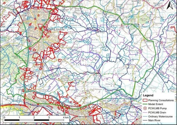
Perhaps a picture is worth a thousand words and so I attach a map of the Pevensey Levels with planning permissions/consultations outlined in red.
It is surely dramatic how such potential developments are encroaching on the catchment area? How much of it should be concreted over?
Advertisement
Hide AdAdvertisement
Hide AdThe geographical area covers a number of local authorities and political constituencies but there is broad consensus over the answers.
The map was prepared by officers within the Pevensey & Cuckmere Water Levels Management Board (PCWLMB) of which I am a director.
I was nominated to that board by Eastbourne Borough Council which has the largest representation because it contributes the largest precept reflecting the fact that Eastbourne has the highest flood risk in East Sussex.
In short my (and other directors) responsibility is to minimise this flood risk.
Advertisement
Hide AdAdvertisement
Hide AdSince the board’s inception I have pressed for it to be proactive in evaluating the impact of planning proposals on flood risk.
For the moment they are evaluated on a case-by-case basis but an extensive piece of survey and modelling work is currently underway to report on the cumulative position.
The board has a byelaw which prohibits the increase of water (flow rate or volume) directly or indirectly into its district without written consent.
Large developments need Board approval to obtain such consent, but sadly the only occasion on which this was requested (the extension of the Brodricklands development)it was granted. To date there has been little or no press coverage of the Board’s activities.
Advertisement
Hide AdAdvertisement
Hide AdThe responsibility of the PCWLMB relates to the mitigation of surface water flooding in conjunction with the Environment Agency (EA) which has retained responsibility for main rivers.
Of course surface water flooding risk is closely related to sea water levels and the ability to discharge into the sea.
The EA has started its work on the Pevensey Bay to Eastbourne Coastal Management Scheme and will shortly be reporting its initial findings. The location of recent drilling work partly reflected the relationship between the coast and the Pevensey Levels.
The principal financial justification is the potential flood damage to over 10,000 homes, principally in Eastbourne.
So what is the relationship with housing targets?
Advertisement
Hide AdAdvertisement
Hide AdUntil surveys are complete we simply do not know the cumulative effect of existing planning developments and permissions within the catchment area. Perhaps we should take the ‘Grampian’ option of stopping further developments until we do?
The Eastbourne Herald reported in May 2020 on my letter to the then Secretary of State under the headline: High Eastbourne housing targets ‘absurd’. At that time the ‘standard methodology’ or ‘mutant algorithm’ demanded that Eastbourne provide 668 additional homes annually, when 200-250 is a more realistic number.
Little has changed on the ground but the White Paper was shelved and the new Secretary of State for DLUHC is contemplating significant changes. Meanwhile local authorities should prepare local plans based on residents’ aspirations for their areas without being a slave to unrealistic targets.