Sussex weather forecast: Will we be hit by ‘mega snow’ and heavy rainfall?
and live on Freeview channel 276
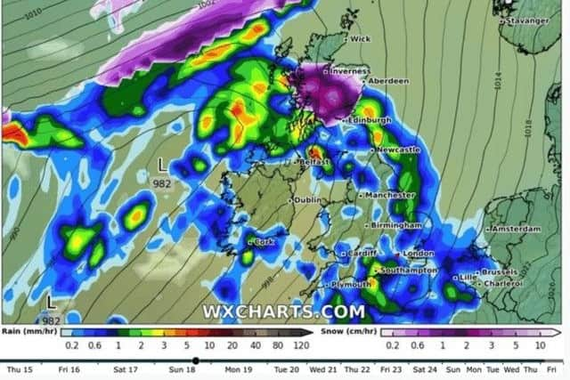
According to interactive weather model WXCharts, the worst of the wintery, chilly and turbulent weather – that has been rampant in the UK recently – is yet to come. The forecast, on Friday (December 16) showed the arrival of treacherous ‘megasnow’ and heavy rain this weekend.
It came just days after the UK Health Security (UKHSA) extended an amber alert for health. The warning stretches to Saturday and Sunday as worsening conditions continue.
Advertisement
Hide AdAdvertisement
Hide AdA government spokesperson said: “Further to the extension of the cold weather alert issued on December 14, the UKHSA is continuing to encourage people to stay warm and look out for those most at risk as freezing conditions persist across the country.

“The Met office had previously issued the alert for all regions of England until midday on Sunday, December 18, and this has now been extended a further 12 hours until midnight on Sunday, December 18.”
WXCharts weather maps showed parts of Scotland were set to get battered by heavy snowfall and rain on Sunday. The worst of the ‘megasnow’ will arrive by 8pm in the evening, the map suggested.
The forecast said most of England would also bear the brunt of the worrying winter weather over the last weekend before Christmas 2022.
Advertisement
Hide AdAdvertisement
Hide AdIt came after the Met Office predicted that, in the early hours of Saturday, areas in Sussex including Brighton, Lewes, Eastbourne, Chichester, Shoreham and Littlehampton could have light snow. The areas had between a 30-50 per cent chance, the Met Office said.
This snow hasn’t arrived but the UKHSA warning suggests more icy conditions and freezing temperatures are to come, after Britain’s arctic blast saw the mercury plummet to chilly depths this week.
The UKHSA warning reads: “This weather could increase the health risks to vulnerable patients and disrupt the delivery of services. Please refer to the national Cold Weather Plan and your trust’s emergency plan for appropriate preventive action."
Have you read?: Vulnerable Sussex pensioner still waiting for Covid and flu jabs despite hospital stays
Yellow warning for rain
Meanwhile, the Met Office has issued a yellow warning for rain – which covers the whole of Sussex. The warning come into force on 6pm tomorrow (Sunday) and runs until 6am on Tuesday (December 20).
Advertisement
Hide AdAdvertisement
Hide AdRain – ‘heavy and persistent at times’ – is expected to bring some travel disruption.
Here’s what to expect, according to the Met Office:
- Spray and flooding could lead to difficult driving conditions and some road closures;
- There is a small chance that some communities will become cut off by flooded roads;
- Where flooding occurs, there is a slight chance of delays or cancellations to train and bus services;
Advertisement
Hide AdAdvertisement
Hide Ad- There is a small chance that homes and businesses could be flooded, causing damage to some buildings.
A Met Office spokesperson said: “Periods of rain are expected to become persistent and at times heavy across parts of southern England and south Wales late Sunday, lasting through Monday, before clearing early Tuesday.
"For the area across southern England, 25-50 mm of rain will fall widely, but the highest rainfall totals are likely to be across the higher ground of Sussex and Dorset, where locally 50-80 mm of rain may fall.”