
Founded with the support of City Parks, the route through the South Downs National Park is promoted by the Brighton & Hove Way Association. When I met the chairman in Southwick recently, he encouraged me to follow the walk, explaining that it could be easily broken up into sections that are accessible by public transport. My kind of walk!
The dream was for it to become a permanent waymarked route but from what I can see on the part I have done so far, that has not come to fruition. I have broken the walk down into six sections and decided to start at the eastern boundary, walking from Saltdean Lido to Woodingdean. I found no signposts for The Brighton and Hove Way and in fact discovered some of the footpaths used are really not the obvious ones!
Don't be put off, this section affords incredible views and is well worth it. It is very special. My estimate for this section is four to five miles. Use my photographs to guide you on the official route – or let's say what I hope is the official route! I used the map provided at www.brightonandhoveway.org.uk and followed it to the best of my ability – going wrong a couple of times and retracing my steps because I wanted to do it properly.
You will find the Brighton and Hove boundary sign just east of Saltdean Lido. Start by walking up Saltdean Park Road, going round the lido, as far as Saltdean Tavern then turn right to walk through Saltdean Oval. Continue along Saltdean Vale to St Nicholas' Church then turn left into Lustrells Vale. You will pass some shops on your left and continue uphill to Bishopstone Drive, where you turn left. Look out for the turning on the right to join the bridleway leading up on to the downs.
As you climb, do pause to take a look back at the view over to Beacon Mill and the sea. At the moment, it is a special time on the downs, with May Blossom everywhere, and you will soon see evidence of that as you walk towards a gate. Continue through the gate and on uphill through the farm, passing Balsdean Farm House on the left and following the path. You will pass through a gate that has two arrows, take the right hand path. At this point look into the distance to the mast – that is roughly where we are heading! Follow the path straight down to where it meets Bazehill Road. Cross the road and continue on but at this point, you need to stop following the obvious path.
Follow the footpath that runs along the line of the fence. You will see an arrow on the fencepost pointing the way. This will lead you to a stile. Please bear in mind you are on the farmer's field but this is a right of way. Follow the path that has been trodden by those before you, it's a pretty straight line to an opening in the fence. I was then taken through a field of wheat and the path was narrow but clear. You will pass through and on through the crops to a gate.
After this, there is supposed to be a straight path down the hill but it is impossible to see. Best advice is follow the wide, clear footpath to the right as it winds down the hill. As you go, you will see a batch of brick farm buildings and this is where you need to head. Go to the right of the buildings and round to go through a gate, then continue straight ahead to join what is known as Snake Pass locally.
You pass through another gate and then it becomes a nice wide path running along a fence, so it is easy to follow. It brings you out to Castle Hill National Nature Reserve and the ancient grasslands that support a rich diversity of plants and animals. As you approach the gate, take a look at the hill in front of you and note the footpath up it. This is what you need to follow and it's easier to find once you know where it is. Pass through the gate into Newmarket Bottom and climb the hill. It is very steep and it takes you to a narrow footpath, which you need to join and follow to the left.
If you don't fancy that, you can follow a longer hairpin-bend route that is less steep. To do this, head on uphill from the gate along the wide, white path. Look for a footpath on the left before you reach the top of the wide white path. It is obvious once you know it is there but you could easily miss it. Bear in mind it takes you on a winding route round to the top of Newmarket Hill, running parallel to the path you have just walked up. That should help you find it!
Now, whichever way you have got there, it is just a case of following that narrow path around the hill. It is pretty clear once you are on it but it is not that wide. The views are absolutely incredible, this is the part that is not to be missed! The path goes through a bank of trees and looks at times like it is not going to go anywhere but stick with it. You should come to a gate taking you out of the nature reserve then continue around the ridge, ending with another climb uphill.
Here, you join a much wider footpath. Turn right to go through the gate and follow the path. You will quickly come to a crossroads of paths, where you turn right to go down what is known as Norton Drive, around the back of Woodingdean. As you walk, you will see Castle House come into view on your left and that is where the bus stop is, if you want to take a note. Carry on walking until you come to a metal gate and continue out to Falmer Road. Turn left and walk past the Castle Hill car park, then on your left, just into Bexhill Road, you will find the bus stop for the No.22 back into Brighton.
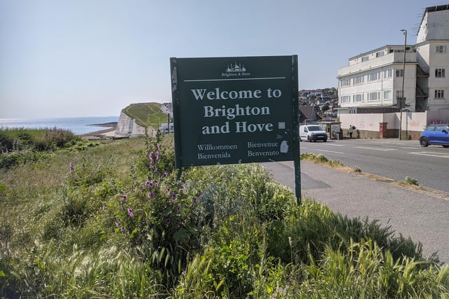
1. The Brighton and Hove Way - Saltdean Lido to Woodingdean
You will find the Brighton and Hove boundary sign just east of Saltdean Lido. Photo: Elaine Hammond
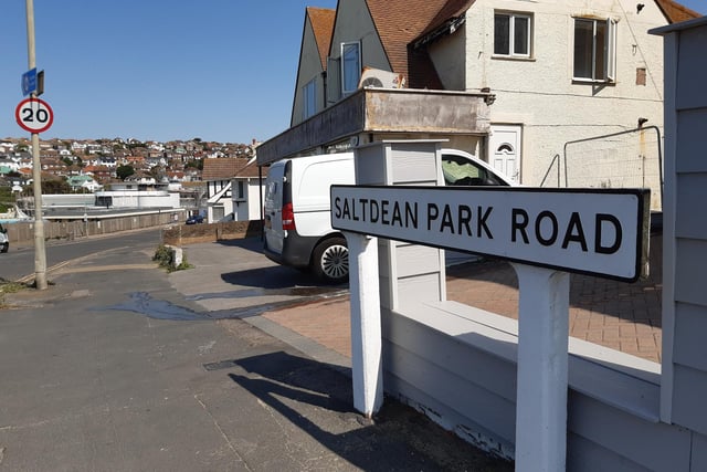
2. The Brighton and Hove Way - Saltdean Lido to Woodingdean
Walk up Saltdean Park Road, to the right of Saltdean Lido Photo: Elaine Hammond
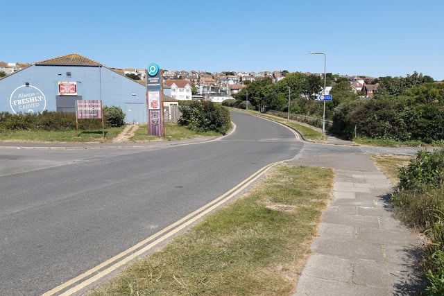
3. The Brighton and Hove Way - Saltdean Lido to Woodingdean
Go as far as Saltdean Tavern then turn right Photo: Elaine Hammond
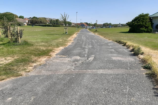
4. The Brighton and Hove Way - Saltdean Lido to Woodingdean
Walk through Saltdean Oval. Photo: Elaine Hammond