
Yellow heat health alert active across Sussex and Surrey as parched lawns highlight 21-day dry spell

A yellow heat health alert is now active across Sussex and Surrey, as the region experiences the latest in a series of heatwaves to hit the UK.
Parts of the South East are expected to reach 30C this weekend.
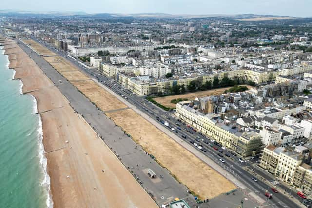
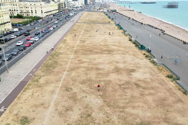
The prolonged spell of hot and dry weather has left parts of Sussex parched, with Hove Lawns pictured looking particularly dry after 21 days without rain.
The alert came into force at 9am on Friday, July 24, and continues until 9am on Sunday, July 26.

The UK Health Security Agency (UKHSA) has warned of minor impacts on health and social care services, including increased use of healthcare by vulnerable people and a greater risk to life for those more affected by hot weather.
There is also an increased risk of indoor environments becoming very warm, while water-related incidents could rise due to risks including cold-water shock and drowning.
NHS Surrey and Sussex urged people to check in on vulnerable friends, neighbours and family members who may struggle more in the heat.
A spokesperson said: “A yellow heat-health alert is in place for the South East and parts of Surrey and Sussex are expected to reach 30 degrees this weekend.
“Please check in on vulnerable friends, neighbours and family who may struggle more with the heat.”
Chichester District Council also shared the alert.
A social media post read: “Please keep a close eye on vulnerable family and friends – and encourage them to refer to the government's guidance.”
The Met Office said that while some areas will see rain and showers this weekend, the wettest conditions are expected to remain largely confined to northern and north-western parts of the UK.
Met Office chief meteorologist Dan Suri said the weekend would bring a temporary change in weather for some areas following a prolonged spell of hot, dry and settled conditions.
He said: “While some areas, particularly in the north and west, will see rain and showers, many places are likely to receive relatively little rainfall.
“For much of southern England, dry conditions are expected to remain the dominant feature, with temperatures recovering quickly next week and the potential for very warm or locally hot weather to return.”
Cloud and rain are expected to affect parts of Scotland, Northern Ireland, northern England and north Wales during Saturday, before more widespread rain and drizzle moves eastwards across the UK on Saturday night and Sunday morning.
Sunday is expected to be the coolest day of the weekend for many areas, with temperatures returning closer to average for the time of year.
However, the unsettled spell is not expected to last long across much of southern England, with dry weather and sunny periods likely to return on Monday and continue into the middle of next week.
Temperatures are expected to recover quickly in the south, with many parts of England and Wales likely to return to the mid to high twenties early next week.
The Met Office said temperatures could reach 30C again in southern and eastern England by Tuesday, with conditions in the South East potentially becoming very warm or locally hot.
There is a possibility that some areas could once again reach heatwave criteria, potentially making this the fourth heatwave episode of the year for parts of the UK.
Currently, heatwave conditions are continuing in isolated parts of England and Wales.
Looking further ahead, southern areas are expected to remain relatively settled and very warm towards the end of July and into early August, although the Met Office warned that conditions could become more unsettled in early August.
People are being urged to take sensible precautions during hot weather, including staying hydrated, avoiding prolonged exposure to the sun during the hottest part of the day and checking on vulnerable friends, family and neighbours.
Those planning to enjoy the water are also being reminded of the risks posed by cold-water shock. The Met Office advises checking water temperatures, wearing a wetsuit if spending any length of time in the water and using a life jacket or swimming buoy.
With breezier conditions expected to develop in southern areas, there are also warnings for people heading onto the water about the dangers of offshore winds.
Lee Pooley, head of safety at Paddle UK, said: “Offshore winds are incredibly deceptive because the water near the shoreline often looks perfectly calm, flat, and inviting. However, the moment you paddle out, a breeze blowing from the land can rapidly sweep a paddleboarder out to sea faster than they can paddle back.
“Our rescue data with the RNLI consistently shows that offshore winds are a primary cause of emergency callouts. We strongly advise everyone to check the weather and wind direction before heading out, and if the wind is blowing away from the shore, do not go.”
Anyone who needs medical help and is unsure where to go can contact NHS 111, which is available 24 hours a day by phone or online.