
Hastings retro with Steve Peak: Defending Hastings from the French
See the latest news from Your World at https://www.sussexexpress.co.uk/your-world
If you haven’t managed to buy a ticket to see the Bayeux Tapestry, why not visit Hastings Castle – no queues, open every day and you can stay longer than 40 minutes! Unfortunately, there is not much of the castle left to see after its brief working life following the Norman invasion. In the following centuries it was largely abandoned, but the town nevertheless suffered several more invasions by the French, so other defences had to be built to protect the borough.
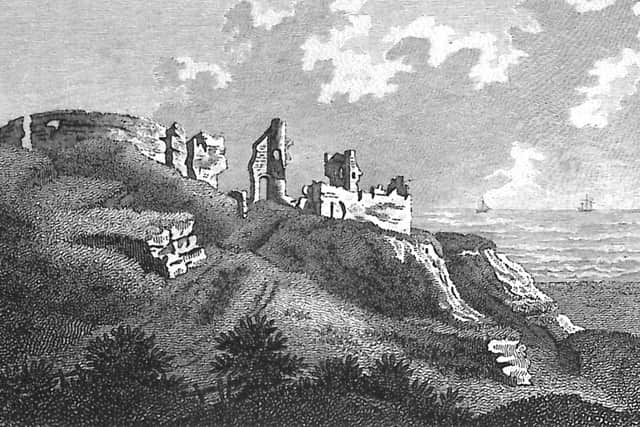

William the Conqueror had built a wooden motte and bailey castle on, or adjacent to, the West Hill a few days before the 1066 battle. About 1070 this was replaced by the stone castle we see today. William divided Sussex into six strips, or Rapes, each with a castle, and placed them under trusted followers to safeguard communications with the Continent. The Count of Eu was given Hastings Castle, in which he built the church of St Mary..
But Hastings Castle never had to survive a siege, and had a largely uneventful life, the highlight being the occasional visit by a king. The violent storms of 1287 that washed away Winchelsea also probably destroyed much of the cliffs that Hastings Castle was standing on. Over half the castle has been lost to coastal erosion and cut-backs of the cliff.
In 1308 Edward II, in a lifelong power struggle with the barons, ordered some improvements to the castle, but it returned to a peacetime footing in 1322 and by 1331 it had been abandoned as a place of defence and was in severe disrepair. As a result, the Dean of St Marys Church were granted custody of the castle by Edward III, which they retained until 1546. They enclosed the castle and built their dwellings inside it, but from then onwards the castle gradually fell into a state of decay from which it never recovered.
In a major attack on the English coast in 1377, the French plundered and burnt Hastings and Rye, highlighting how impotent the castle was. All Saints Church and St Clements Church were both probably destroyed; no houses in the Old Town today date from before 1377.
As a result of the French hostilities, one of the first coast defence laws was passed in 1403. Henry IV ordered that watches be kept along the south coast. A network of fire beacons was set up on the coast, with links inland. This was to be the main method for signalling the presence of enemy ships in the Channel until the end of the 18th century. Each beacon also mobilised militia forces in its surrounding area, mustering bands of local people to fight off invaders. The system became highly organised during the 16th century, particularly when the Spanish Armada was expected in 1588. Fairlight Head always played a prominent role in this communications network, being the highest land between Beachy Head in the west and Hythe in the east.
During the Protestant Reformation that began in the 1530s, Henry VIII broke the Church of England away from the Catholic Church. As part of this, St Mary’s Church in the castle, along with much other land in Sussex, was passed in 1546 to Sir Anthony Browne, a prominent courtier. By this time the castle was in complete ruins. There was little more than the outside wall, plus a gate with chambers over it, some vaults and fragments of buildings.
Then in 1548 the French attacked Hastings again, burning about a tenth of the houses in the town. In this decade of increased trouble with France, a big wall of stone may have been built across the south end of the Old Town, from the junction of High Street and George Street to the bottom of All Saints Street. However, it is possible that the Town Wall, as it was known, had actually been built there in about 1385, and it was improved in about 1548. If it was built entirely in the mid-16th century, it would probably have been mainly anti-French, while a wall built c1385 would have been protecting the town from both the French and coastal erosion. Some of the wall survives in Winding Street.
Whenever the Town Wall was built, it is assumed that there were no buildings, apart from fishermen's wooden work-huts, on the seaward side of it at that time, having been lost to the sea (and the French?). All buildings south of the wall - including all George Street - therefore date from after the mid-16th century. The beach level against the south side of the wall was several feet below the ground level on the north side, and the wall itself could have been about 20 feet high in places. The wall included three gateways. The Sea Gate was at the bottom of High Street, by No 58; it had been demolished by 1808. The Bourne Gate was where The Bourne road is today, by Winding Street. And the Pulpit Gate was a pedestrians-only gate at the bottom of All Saints Street.
In July 1690 the English and Dutch navies were defeated by the French at the Battle of Beachy Head, and the French later attacked Hastings from the sea, but without landing. As a result of this French hostility, two sea-facing artillery batteries were built in Hastings, one on the eastern corner of Rock-a-Nore Road and All Saints Street, where the cafe is today, and the other in what is now Pelham Place, just beyond the west end of George Street. Both 1690 batteries were superseded in 1759 by a large battery built where the west end of the former boating lake is today.
In April 1805 work started on building 74 large Martello Towers along the south coast between Folkestone and Seaford because of the threat of yet another French invasion. These had a large cannon installed on the roof, able to rotate on rails. However, Nelson’s victory at the Battle of Trafalgar in October 1805 made these heavily fortified towers unnecessary, but work continued on them, not being completed until 1808.
The nearest to Hastings, No 39, was at West Marina, where today is the junction of Grosvenor Gardens and Sea Road; it was lost in the late 1870s. From here a line of them went west to Eastbourne. Nos 40-42 were on the beach at Bulverhythe and No 43 was on Bulverhythe Cliff, opposite the Bull Inn. To the east of Hastings, the closest was No 38 at Cliff End, from where they were spaced at about 600 yards eastward.
Each tower required about 400,000 bricks, and several large brickfields were set up to make them, including one on the edge of the coast between Glyne Gap and Galley Hill. Bricks, lime and other materials were supplied in this area by Henry and Thomas Farncomb, and Mark and Thomas Breeds, who all made a profit of many thousands of pounds. Along with Edward Wenham, they began the erection of Wellington Square and Russell Street after the Battle of Waterloo in 1815.
This expansion of the town prompted the wealthy Pelham family, who had owned the derelict castle since 1591, to cut back the cliff on which the castle stood and build Pelham Crescent. St Mary-in-the-Castle Church in the Crescent, built in 1828, is currently closed, while in the castle the remains of St Marys Church, built c1070, are open!