
West Sussex MP says ongoing flooding problems are 'not acceptable'

The MP for Bognor Regis and Littlehampton said she shares public concern about ongoing flooding.
Following weeks of relentless rainfall, road closures remain in place, with A29 highway improvement plans also delayed, as emergency services and council workers battle rising water levels.
Alison Griffiths MP wrote on social media: “Thank you to everyone who has left a comment on my recent Facebook posts; several hundred and counting. I am reading through them all and noting down the points that are being made. I am hearing your frustration, your anger, loudly and clearly.
“First, if you have been affected, or you need my assistance with any flooding related matter, please can you write to me directly with an overview of the issue. I don't want any urgent problems to be missed amongst the wider strength of feeling that is being expressed. The quickest route is via email: [email protected].
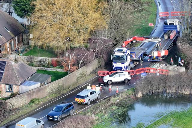

“Second, I agree with you. Entirely. The ongoing flooding problems we're experiencing are not acceptable. All the points that you've raised – the building on flood plains, inadequate drainage, the need for dredging, for channels and gullies to be cleared, for the catchment basin upstream to better retain water, and yes, for the agencies responsible for sorting it to be held accountable – are ones that need to be addressed.”
In the immediate term, Mrs Griffiths said she is ‘speaking again’ with West Sussex County Council, as the lead local flood authority, the Environment Agency, and Arun District Council.
She added: “I am also in touch with the Flood Avoidance Community Taskforce (FACT) about the long-term action needed to protect homes and businesses from sustained flooding. I understand that the Arun Flood Forum will be convened imminently to address the incidents across the district. All of the agencies involved in flood response and prevention attend, and I will ensure your voices are heard and your concerns are taken seriously, by them.
“I will keep residents updated on the outcomes from these conversations, what they are proposing in terms of ‘quick fixes’, and then what we need to do locally – and what I need to take to Westminster – to get this sorted for the long-term.”

Meanwhile, the managers of a caravan park have stepped in to reassure owners and holidaymakers, after images showed a part of the site underwater.
Dramatic photos appeared to show entire rows of homes partially submerged at Riverside Caravan Park, on Shripney Road.
Emergency pumping equipment was set up in the Tesco superstore car park, across the road, to help deal with rising water levels on Tuesday.
The aerial images showed floodwater stretching across large areas of the site, engulfing pitches and surrounding parked caravans, as water levels continued to rise.
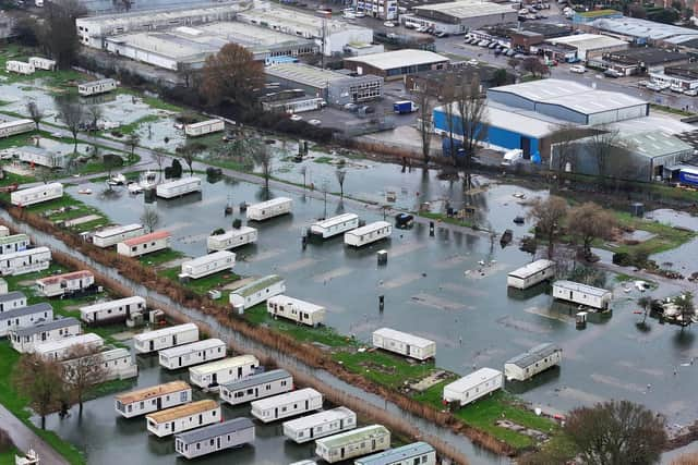
The caravan site management team said: “Riverside has experienced a limited amount of surface water following recent weather conditions. This is not unusual for this time of year and is something the park has historically managed without issue. Water levels have already begun to recede and have not reached, nor are they expected to reach, a level that would pose any risk to caravans or park infrastructure.
"The area featured in the published images and footage is not currently in operational use, there has been no impact on our day-to-day park activities and we do not expect that to change. Riverside is scheduled to reopen on 1st March and will resume normal operations from that date."
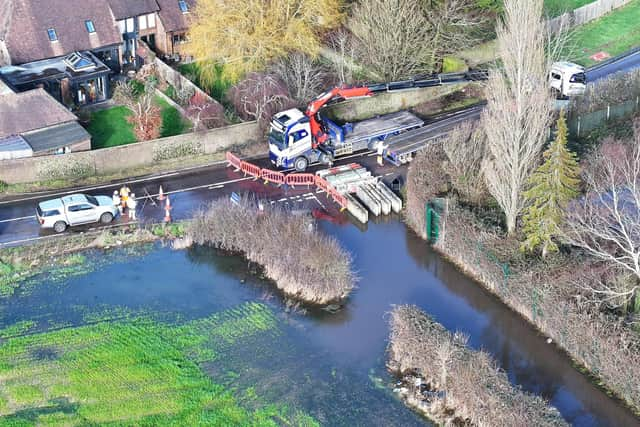
West Sussex Highways confirmed that Lower Bognor Road remains closed, after an inspection on Wednesday morning.
It added: “Flooding remains across both carriageways (northbound and southbound), so the road will remain closed at this time. We are monitoring conditions and will provide a further update when the situation changes. Please avoid the area and follow the signed diversions.”
B2166 Lagness Road – from the Hunston Roundabout to the Walnut Tree – is ‘currently open’ and the county council has ‘requested for the signage to be removed’.
Elsewhere, the flooding has caused a highway operative to be 'struck' by a car, highlighting the dangers posed by drivers ignoring road closures.
This incident on Monday morning (February 9) happened A29 Shripney Road – at the Saltbox Roundabout – in Bersted. The road has been closed since Monday, February 2, due to major flooding.
The county council has now reiterated its warning for residents ‘not to drive through flooded roads’.
A statement read: “Whilst the council understands the frustration road closures caused by flooding present to drivers, driving through them can cause further issues including delaying opening the road, pushing water into residential homes as well as potentially negating the driver’s insurance should their car break down due to water ingress.
“It is also dangerous to those highway operatives who are on site to try and resolve the issue. One of our highways team members was struck by a white Land Rover which forced its way through a road closure.
"Luckily the operative was not injured but the incident has been reported to the police and any witnesses are urged to contact the police on 101.”
Undeterred Highways teams continue to work at the site – with a temporary ramp being erected over the flooding at Sack Lane.
The latest county council update, at 1pm on Wednesday, read: “Our contractors have finished installing a temporary ramp over the flooding at Sack Lane to enable vehicle access for all residents. This will remain in place until the weather conditions improve and the road is clear of flood water
“Shripney Road will remain closed to all non-residents and non-local business users due to the current water level.
“We are working on site to try and relieve the wider flooding issues on the A29 and will provide further updates as necessary. We thank residents for their patience and understanding.”
As a result on the ongoing road closure, a community highway scheme – due to start on Monday, February 16 – has been delayed.
A previous announcement of the planned works prompted criticism from some residents, who questioned why flood management and drainage issues were not being prioritised.
The works – intended to ‘improve safety for pedestrians and road users’ – were due to be undertaken from February 16 until March 17.
The ongoing flooding reflects long-standing issues in the area, according to county and district councillor Keir Greenway, a lifetime resident of Bersted. Following widespread flooding in October and November 2023, a formal Section 19 flood investigation examined why Shripney is particularly vulnerable.
“Shripney sits in a low-lying catchment, with water naturally draining through the Shripney Manor Ditch into the slow-flowing Aldingbourne Rife,” Cllr Greenway said. “The village also relies heavily on roadside drainage (ditches, pipes and gullies) to move water away during heavy rain."
He said the 2023 flooding was caused by several overlapping factors rather than a single failure.
“Exceptional rainfall from multiple storms fell on already saturated ground, groundwater levels were already high, and the Shripney Manor Ditch exceeded its capacity and came out of bank,” he said.
“When the ditch is full, highway drains can’t discharge properly, so water backs up and surcharges onto the road. At the same time, the foul sewer system was overwhelmed and discharging from manholes, and some highway gullies were partially blocked by silt and tree root intrusion.”
Cllr Greenway warned that climate change is increasing the likelihood of similar events in the future.
An updated Environment Agency flood alert, for the Aldingbourne and Barnham Rifes, reads: “High river levels on Thursday may lead to flooding.
“Flooding is possible on 12 February, as another 10mm of rain is forecast on Wednesday evening.
“The Aldingbourne Rife is high following weeks of rain. Minor flood impacts affecting fields, roads, land at Riverside Caravan Centre, and the car park at Tescos on Shripney Road will continue. A band of rain is forecast on Wednesday evening.
"From 8pm Wednesday, minor flood impacts could affect Barnham Road and Lake Lane, Barnham. The Barnham Rife should not rise higher than Friday. Through Thursday, the Aldingbourne Rife should rise less than ten centimetres before beginning to fall in Bersted by Thursday evening, although it will not fall far or fast. Further river rise is possible Friday.
“We are closely monitoring the situation .We're clearing debris screens in Barnham and pumps at Felpham are running.
"Consider activating any flood protection products you may have including in Barnham. Avoid roads that flood (Barnham Road and Lake Lane).”
This alert was to be reviewed by 8pm on Thursday.
West Sussex County Council stepped in to assure residents it is doing all it can to keep the county moving.
The council said that, since September, the county has had above average rainfall, reaching up to 190 per cent above average, with more heavy rain forecast. The persistent rain has caused widespread disruption, including road closures due to standing floodwater and a sharp rise in potholes.
The council stressed that highway drainage cannot always cope during prolonged heavy rain, and flooding may be due to overflowing watercourses, full drainage discharge points, blocked private land watercourses, or because pumping would cause more water to flow in. Where safe, roads will remain open with warning signs, but full closures and diversions will be put in place if there is a safety risk.
In January, 4,500 pothole repairs were logged – 1,500 more than January 2025 — with a further 1,400 raised in February. Temporary repairs are being made where necessary until full repairs can be completed in better weather. Over 22 crews are working weekdays, plus nights and weekends, completing repairs in an average of 15 days despite increased demand.
Teams respond to flooding reports, manage safety risks during storms, and work with landowners to keep non-council watercourses clear. Residents are advised to check before travelling, not ignore road closures, and be aware of hidden hazards in floodwater. The council acknowledged frustration and said it is working as hard as possible to resolve the issues.